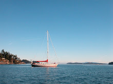
Friday, August 27, 2010
Saturday, August 21, 2010
Thursday, August 19, 2010
Tuesday, August 17, 2010
Saturday, August 14, 2010
Respecting The Cape
Tomorrow, Sunday August 15th, we will leave the protection of our anchorage, Qasigissat, at first light. The early start is a concession to the brash and broken sea ice which is difficult to see, unlike icebergs that can be seen from a long distance and are more easily picked up by radar. By covering as much distance as possible before dark, we lessen our chances of hitting the small but still dangerous ice that tends to be closer to shore. Icebergs are carried south by the East Greenland Current and will continue to be a potential obstacle for the first half of the crossing.
Last night we took advantage of a break in the rain to tighten Snow Dragon's forestay which had stretched from all the sailing we have done over the past few months. This entailed taking off the jib and dismantling the furler drum to reach the turnbuckle. A task made pleasant by the unusually warm evening. After sleeping in, something we will not be able to do during the crossing. We enjoyed a leisurely morning before going to shore. The morning drizzle had subsided and we were happy to find blueberries amongst the lush vegetation of the valley. Something we did not find in Prins Christian Sund.
Back on the boat, Frances baked ginger cookies and energy bars for the passage. While Krystina sorted the blueberries that needed to be made into jam from the one we wanted to keep for eating. Apart from preparing Snow Dragon, we like to make sure we have food pre-made for the first few days of the passage. We also pulled in some more weather faxes on the SSB to double check that nothing sinister had formed. Before we leave in the morning, we will also download a new GRIB file on the satellite phone which will give us more detail of the wind and wave conditions in the immediate area. After dinner, the rain that began during our walk was still showing no signs of letting up. With the dinghy still needing to be brought on deck and deflated, we geared up and got the task done. We also changed propane bottles so we would not run out during the passage before diving back inside to dry off. Our only wish aside from a good crossing, is for the rain to stop and the sky to clear so that we can see Kap Farvel as we sail past tomorrow.
Friday, August 13, 2010
Slippery Granite And Erratics


The next day the fog was lower but at least the rain had stopped. We decided to head in the direction of the highest peak in the area and see if the visibility was reasonable enough to continue up to the 315 meter summit. On the way we were surprised to see ferns growing contently amongst the rock. Both the rock and moss were very slippery and we had to adjust our route several times when it became too challenging. Near the top, steep snow turned out to be the only viable way up. Krystina waited while Frances scrambled along the snow to a viewpoint. It was too wet to make it all the way up to the summit but the view during our hike was still spectacular.

That evening we motored 11 miles to Puiatoq, to help break up the trip back through the sound. Once we got under way we saw another sailboat coming towards us. They called us on the radio and introduced themselves. Turned out they were a French boat, Baloum-Gwen, on their way to Ammassalik on the east coast. It was only the sixth sailboat that we had seen during our month in Greenland. We wished each other a good trip and waves as we passed.
A few miles before the entrance to Puiatoq (60' 08N 43' 36W), Frances spotted a couple of bearded seals hauled out on floating pieces of ice. We sailed close to one and were able to clearly see its whiskers and front flippers with large claws, before it slid into the safety of the water. There was even one seal floating on a piece of ice in our anchorage, it remained while we anchored and did not seem alarmed by us.

We went into the bay laughing at the little erratics that lined the anchorage, thinking that nature definitely has a sense of humor. We had planned to visit them in the morning but the return of the rain, made engine room tasks more appealing. The rain continued and by the afternoon we decided to brave the wet and move the 20 miles Qasigissat our planned departure anchorage. A couple of gusts provided enough wind for us to sail downwind under staysail for an hour before calming. The lack of motor made it easier to appreciate the sound of the waterfalls that were raging down the mountains, in varying forms. Some flowed straight down, others had a more complicated pattern that zigged along the face of the rock. After saying goodbye to the sound, we turned the corner and were once again impressed by the change in the color and shape of the mountains.
For more photos please click on East Prins Christian Sund Album.
Wednesday, August 11, 2010
Shades Of Gray

Waking up to rain, fog and gray sky is part of being in Greenland. Clear, bright sunny days are few and far between. This morning the sound of the raindrops hitting the deck meant that the long exploratory hike we had planned would need to be rescheduled. On days like this, it is easy to come into the pilothouse and only see gray and give in to the overwhelming desire to go back to bed. If we did this, our time in Greenland would pass by in a blur during brief breaks in hibernation.
Taking another look, it becomes easier to see the shades within the gray. The sky's lack of texture as it stagnantly sits above us, helps its tone of gray to border white. Closer to the water, the granite takes on a range of shades including charcoal gray. Keep looking at the granite and gray gives way to areas of pink in the rock and the green of the grass. Suddenly bed is no longer the favored option and looking at the numerous miniature raging waterfalls that have been created by the rain seems much more exciting.
After taking in our surroundings, there is never a shortage of tasks on Snow Dragon. Sometimes we can get away with curling up with a good book but generally our spare time on board is spent crossing off items from our never ending list. This morning we pulled in an extended weather forecast on the SSB to try to get a handle of the big picture. Our time in Greenland is rapidly coming to an end and we need to find a good crossing window to the Azores before the end of August. Ideally no later than the 24th, to avoid being caught in the strong gales that intensify in September.
Whether or not we go ashore today will be our decision. Aqigssiat has proven to be an excellent anchorage in easterly quadrant winds and there is no swell preventing us from leaving Snow Dragon. The slippery, steep rock will curtail much more than a leg stretch but a short walk will probably still be worth the effort. For now the rain persists and boat tasks have been temporarily been put aside for more creative pursuits.
Tuesday, August 10, 2010
Wind Filled Weekend

Our confidence in being able to anchor at Igdlorssuit Havn (60' 10N 44' 04W) was high. It was the anchorage we had used in a much stronger gale that came through when we first arrived in Greenland. With both the wind and swell fighting against us, it was difficult for Krystina to keep Snow Dragon in position while Frances let out the large amount of chain that was needed for the deep anchorage. Our first attempt failed when we ended up dropping in 50 meters instead of 30 meters. To increase the chance of the anchor hitting bottom before we got blown into deeper water, we decided to leave the anchor hanging on 20 meters of chain while Krystina repositioned Snow Dragon. On the second try we succeeded in anchoring in 25 meters.
It was too rough to go ashore and we settled into being boat bound for the day. After dinner, while Frances was in the middle of a painting and Krystina was putting the final touches on a blog post. Snow Dragon got blown sideways and we could hear the anchor dragging. The depth sounder showed that we had dragged into deeper water so there was no chance the anchor had securely reset itself. We decided to try the spot we had used during the last gale but found with the different wind direction it put us too close to shore. After a few failed attempts we moved back close to where we had dragged and succeeded in re-anchoring. We left our chain snubber off hopping it would help keep Snow Dragon into the wind, feeling that enough of the shock-loading would be absorbed by the 90 meters of chain.
The next day showed no reprieve from the wind which meant that going to shore was still not an option. By evening, the wind reduced enough that the tide was able to turn Snow Dragon beam to the swell. Making it difficult to sleep with the uncomfortable motion and sound of the waves slapping Snow Dragon's hull. We were rudely awaken by a loud bang which Krystina discovered was caused by a long piece of glacier ice running along Snow Dragon's port side. She decided to stay up and watch for ice but aside from a few pieces on the far side, nothing else appeared.
That afternoon we were finally able to make it to shore. We were both slightly paranoid about being able to get back to the dinghy after our last hike at Igkirssuit Havn entailed and unplanned swim. With 20 meters of extra line added to the already ridiculously long painter, we felt we could spend and hour and a half looking for the hat without getting stranded. Sadly the had could not be found but were glad we had made a second attempt to find it and we enjoyed another walk in the glacial valley.

The tide was against us, making the 25 miles take longer than usual. Finally at 11pm after five and a half hours of motoring, we arrived at Aqiqssiat. The anchorage looked incredible, its bubbly granite rock still shinning in the fading light. Frances was already planning hiking routes as Krystina watched the depth sounder. We were fairly close to shore before the depth dropped below 100 meters and started to gradually shoal. At first it looked as if we were too close to shore but after getting the anchor set, we realized we were much farther than it had appeared in the dim light.
For more photos please click Wind Filled Weekend Album.
Monday, August 9, 2010
Heading Back To Prins Christian Sund

From a distance it looked as if the exit to the channel was completely blocked by a large iceberg but on closer inspection we realized there was plenty of room. We slowed down to push through the brash and photograph the berg with it blue band of clear ice as we glided past. Headwinds persisted and aside from a brief sail we motored in order to make the 35 miles in the daylight. There were less icebergs than there had been when we had made our way north. Some of them we recognized but there were also a few that looked like new arrivals from Greenland's east coast.

The mountains along Torssukatak, one of the passages that lead to Prins Christian Sund, were still as spectacular as we remembered. With their detailed intricate peaks standing out from their massive granite bodies. Near Prins Christian Sund we decided to anchor at Stordalens Havn but found the rapid shoaling and erratic depth not appealing. After reversing out of the shallows we decided there was enough light left to make it to Kangerdluk (60' 13N 44' 18W), the next fjord. Where we found excellent holding in more reasonable depth. The only potential hazard was a bus sized iceberg that was slowly floating around the anchorage. It seemed content to stay on its side of bay and the sole disturbance was the swell coming up the fjord.
For more photos please click on Nanortalik-Prins Christian Sund Album.
Sunday, August 8, 2010
Nanortalik, Old And New

Our main reason for going back to Nanortalk was that it had the most convenient fueling situation. Two guys on the quay took our lines as we came alongside, making it an easy docking. We headed off to the gas station to arrange for a fuel truck but there was no attendant. Our search took us into the Nanco Oil Cafe that proudly serves "fast food, junk food". The woman behind the counter understood that we were trying to buy diesel for our boat and organized someone to meet us. While we waited, we had plenty of time to take in the menu that was a cross between McDonald's and a kebab stand. After watching several orders being prepared, we decided that we were learning more about fast food then we really wanted to know and headed outside to wait in the sunshine.
The fuel truck driver explained that there was a 200 Dkr charge for coming out to Snow Dragon that we could avoid by bringing her up to the dinghy dock in front of the gas station. Knowing the dock from our previous visit, Frances felt the 200 Dkr would be money well spent. Fuel in Greenland is tax-free as a way of subsidizing boat travel. Which is highly relied upon due to lack of roads and scattered remote communities. At 4.27 Dkr per liter our bill rivaled the low coast of fuel in Cuba. Starting in 2011, fuel will no longer be tax-free which hopefully will not negatively impact those who depend on more traditional methods of income like hunting and fishing.
With our main town task complete we decided to walk out to the old side of town which we had missed on our previous visit. The older buildings were better built and maintained than those in the modern town. They were picturesquely sited on the rocks around the small boat harbor. From the signs posted on the outside describing their original use, we learned they now housed various museum exhibits.
Back on the boat we sat out on deck watching the kids who were taking the 18C temperature seriously and jumping into the water from the quay. Most were in wet-suits but one kid braved the cold water in surf shorts. The crew of a fishing boat docked nearby seemed to have a similar idea and were testing their survival suits. Jumping off both the quay and their boat.

Two young kids had taken an interest in Snow Dragon and were sitting on the side of the quay watching us. We said hello and they smiled back, shaking their heads when Krystina asked if they spoke English. They had gone over to watch the fishermen playing in the water but soon returned. Krystina was working on her computer in the pilothouse and the kids climbed down onto the boat for a closer look at the photos that were being downloaded. We understood that they were just curious and let them stay until we were ready to eat dinner. Then Krystina politely motioned for them to return to the dock which they did with smiles.
Shortly after going to bed, we realized that we had forgotten our midnight check-in with coastal radio. Krystina called them and started to apologize but then saw that is was only 12:30, well within the limit. In the morning we took the dinghy through the fog to a dock that was closer to the two grocery stores in town. We had done most of our provisioning in Qaqortoq but had saved some of the more delicate items like eggs for Nanortalik where it was easier to get them back to the boat.
On the way to the museum, we made one last stop at the tourist information office to look at the tupilaks they had for sale by local artists. Tupilaks are carvings that originated out of contact with Europeans who wanted to see what the mythical creatures that the shamans used to ward of enemies looked like. Frances chose a large pendant tupilak made out of reindeer bone and Krystina purchased one carved out of a seal tooth.

At the museum, one of the more well done exhibits was the boathouse which showed how the traditional kayaks and umiaqs were built. Complete with photos of children learning to paddle kayaks with out-riggers added as training wheels. Frances tested a wooden replica of a kayak on rockers which showed the instability and skill needed to balance it. She found it impossible to get into and ended up on the floor, thank full that it was not the water. Without trees, Greenlanders used scrub birch and willow to make the ribs of kayaks and seal skin to cover them. Drift wood was used sparingly as it was not a common item. Umiaqs were the women's boat, which could be used like cargo ships to carry household items from one place to the another. Inverted they doubled as a travelling shelter, once at the summer camp the whale skin covering was removed and used as a tent roof.
While we wandered through the different buildings, Krystina came across a copy of 'Greenland Today'. The articles conveyed a more positive outlook on Greenland's assimilation of western culture than we were personally witnessing. The articles were in both Dansih and English and in many ways the magazine read like well-written propaganda. It did not help that one of the interpretive displays at the museum, discreetly mentioned that the Danish government and Church had deemed the people legally incompetent. This was used as a justification for resettling them in modern villages. The last forced relocation took place in the 1960s.
Before untying our dock lines, we took one last look at the cleats which had a female figurative form and wondered if that had been intentional or a consequence of design that no one had noticed. Our second visit to Nanortalik had been more enjoyable but we still left feeling that Greenlanders had yet to reconcile traditional and western life. While there were elements of Inuit culture in evidence we felt that it was mostly for the benifit of the tourists. The fasionably dressed teenagers would have looked at home in any major city.
For more photos please click on Nonortalik 2 Album.
Saturday, August 7, 2010
Dried Fish And Ruins

The muted, patchy pattern of the mountains reminded Krystina of a calico cat as we motored into the unnamed and mainly uncharted bay (60' 33N 45' 17W) on the west side of Unatoq Fjord. The depth shoaled evenly and we were able to anchor fairly close to shore without discovering any underwater surprises. On shore the bright yellow buttercups were vibrant against the dull sky and dilapidated houses that stood near the ruins. The rectangular shape of the Norse stone foundations immediately differentiated them from the round bases used by the Eskimos. More recent inhabitants had left a broken down barbwire fence that gave an imprisoned feel that we hoped did not exist when the Benedictine convent and other structures including a farm were in existence.
When we walk amongst ruins whether they be Norse or Eskimo, we reflect on our own experience in Greenland. Did they enjoy picking berries as we do or was it more of a chore? Was the taste of the glacier water satisfying or was its icy temperature a curse? Did the beauty of the landscape make up for the hardship and isolation? Questions that only those who inhabited this area long ago can answer.
For more photos please click on Norse Album.
Friday, August 6, 2010
Beneath The Fog

The tight channels at Sardloq where we had watched the seals being skinned were even more impressive now that we could clearly see the granite rock beside us. It was tempting to stop and spend more time at the community. Especially when a few of the residents came out and waved but we knew the fog's absence was only temporary.
As we neared Sydproven we could see that bergs still dominated the entrance to Zakarias Havn and had possibly grown in number. There was also a large iceberg, grounded in front of the village. At Akuliaruseq which consists of a couple of houses and a church, we looked at an inviting bay that we had bypassed on the way up due to a resident iceberg. The iceberg had relocated but the bay was open to swell and looked less appealing in the fading light.
With wisps of fog moving in we decided to push on to Unatoq, where we knew we could find a good anchorage. With the above average visibility, we chose to anchor at Igpik (60' 30N 45' 19W), behind the spit on the north side of the island. Which we had previously avoided because of thick fog and large icebergs. The sun was setting as we dropped the anchor, bringing out the color in the pebbles on the spit and the blue of the iceberg towering behind. Once we were firmly anchored the wind increased dislodging a local powerboat that had been at anchor up wind of us, luckily the crew was on board and realized what was happening. When they were only a boat length away, they quickly started their engine and motored away from us waving cheerfully.

The whiteout that followed the next morning inspired hibernation. By noon the shore was beginning to make an occasional ghostly appearance. Frances had wanted to paint one of the icebergs sitting near us but that to was cloaked in white. Eventually the fog cleared and after Frances finished her painting we went to shore to take in the view from a small hill. By the time we got to the top, the fog was beginning to drift back in. Making the setting seem surreal with Snow Dragon anchored off the white sand beach, bergs in the background and mist floating gradually closer.
For more photos please click on Unatoq2 Album.
Thursday, August 5, 2010
Experimental Agriculture

Tucked in between gentle granite hills is the Upernaviarsuk Research Station, an experimental farm trying to manipulate agriculture to suit the arctic. Even below the arctic circle, southwest Greenland is above the northern tree-line and not a land of fertility. Looking at the hay fields and perfect rows of cabbage. Maybe Eric the Red was not so far off when he named Greenland, a name he had selected to entice settlers.
Our interest ranged from curiosity to practicality. We wanted to find out what they were able to grow successfully and thought it might be the ideal source for purchasing good quality vegetables. Aside from a speedboat full of teenagers that arrived after us, the farm was quiet. A sign near the dock showed where the Norse, Eskimo and Colonial ruins were located but gave no additional information. There were two Danish men working in the greenhouse but they did not acknowledge us. We figured that since it was Sunday, they were not interested in dealing with visitors.
We wanted to continue looking around but all the fields were fenced. Not being sure of the etiquette we decided to walk out of the main farming area to pick blueberries. The land had been grazed and blueberries seemed to have been a popular item on the menu. We were about to give up after only finding the occasional single blueberry when we discovered a small steep area that had been missed. By the time we had finished, there were enough for another batch of jam.
On the walk back we could see from a distance that our dinghy had been relocated to make room for a skiff. Once at the quay we realized it had been moved to an inaccessible location. It was tied with no slack to the outside aft cleat of the skiff, making it impossible to reach from the ladder and the swell that was rolling in did not help bring it any closer. It took all of Frances' courage to be able to hook the skiff with her foot and jump down onto the slippery bow of the speedboat. She was then able to reach the dinghy, pick up Krystina and return to the boat. Snow Dragon was sitting bow towards the swell, which made the motion comfortable, but we still selected several alternative anchorages in case the wind continued to increase. Neither of us wanted to move and were content to put up with the motion.
Only the group of teenagers that were there presumably to learn about farming, were evident when we returned in the morning. Eventually we found a woman by the greenhouse who was able to explain that the gardener was in town and we would have to wait until he returned. We debated staying but felt that they were not that keen on selling their produce. When a small group of tourists arrived, we noticed they were also being left to wander on their own without any interaction from the staff, we knew that moving on was the right decision.
The bright, sun-lit farm that we arrived to reminded us of Norway. While the clouds that filled in as we left took some of the cheeriness, it still failed to bring our attention back to the fact that we were in Greenland. Maybe its because we associate the area with the harsher realities of the arctic climate, not the soft nurturing aspects of nature. Or that we left without gaining a better understanding of the project's viability. Perhaps agriculture will have a bright future in Greenland if global warming is here to stay. For now the sheep need to be kept indoors during the winter and greenhouses still play a vital part in Greenlandic gardening.
For more photos please click on Upernaviarsuk Research Station Album.
Tuesday, August 3, 2010
A Second Look At Qaqortoq

By our second morning at Sildefiorde, the rain and fog returned leaving no trace of the previous summer day. We contemplated staying another night to avoid moving in the pouring rain but decided the most productive way to spend a wet day was for us to go back to Qaqortoq. Where we were planning to provision for our upcoming passage to the Azores. We were completely soaked by the time we arrived and were not looking forward to anchoring outside the harbor. Which would have entailed a long dinghy ride in the rain. Once again we had crossed paths with Resolution and they suggested we might find space at the wharf ahead of the large ships. The spot was occupied by two Danish survey vessels that were rafted alongside. After not being able to raise them on the radio we decided to go back our and look at our anchoring options. By that time the wind had come up and the anchorage looked even less attractive. We went back into the harbor one more time to try to get the attention of one of the survey ships to ask if we could raft up to them. It turned out not to be a problem and we waited patiently for a local power boat who was tied up to them to load its passengers and leave.
The crew of the Danish vessel kindly helped us secure our lines. They had remembered seeing us at Nanortalik and we talked with them about our plans before going inside to warm up. After taking the time to change the engine oil, the rain let up to a more reasonable drizzle and we ventured into town to get a start on some of our errands. Krystina spent some time with Qaqortoq Hotel's temperamental WIFI, updating blog photos. While Frances went to the grocery store to make a start on the provisioning.
Our plan had been to only spend one night but we were having an enjoyable time getting to know the survey vessels and still had a list of tasks that would make another night productive. A small cruise ship came in and moored behind us. Some of the Finish passengers stopped to photograph Snow Dragon and we exchanged greetings. The tourist office had told us that we could join the cruise ship group for a tour of the Great Greenlandic Fur House, the local tannery, but we decided that joining a tour of 40 people was not the appropriate forum to ask our economic and cultural questions regarding the Greenland fur industry.
For our second round of provisioning we decided to use our dinghy instead of trying to pass groceries across the two survey boats. We were mainly in need of bulk items like UHT milk, sugar and flour, which are relatively easy to find in Greenland. The fresh fruit and vegetables were not in good shape and we opted to try some of the frozen mushrooms and berries instead. After stowing our shopping, we stopped at the Thai restaurant in the center of town for coffee. Their menu looked interesting and we made a dinner reservation. However, we quickly canceled it after hearing from one of the other boats that it was the worst Thai food they had ever had. We might have given it a second chance but not at Greenlandic prices.
Before going back to the boat we made one last stop at the hotel, where we met a newly arrived Danish couple. they were sitting in the hotel's cafe and invited us to help them finish their french fries. We asked them what brought them to Greenland and they explained that they would be teaching at the high school in Qaqortoq. Our discussion drifted between education and Denmark's involvement in Greenland. The story of Danish sovereignty over Greenland lacks a fairytale ending and reads similarly to that of other colonial powers, smothering culture and exploiting people and resources. The couple came back with us to meet Snow Dragon and joined us for a tour of one of the survey vessels.
Frank the engineer on Birkholm gave us an in depth tour of the ship's systems and explained that all Danish naval ships are designed with an interchangeable "container" so that vessels can easily be re-outfitted for different missions. One of the surveyors showed us the 3D imagery they get from the data they collect using a highly sophisticated depth sounder. Both the tides and the ship's movements are corrected for and the resulting image is impressive, clearly showing the topography. When they return to Denmark in October, the surveyors will spend the winter correcting their data and looking for any discrepancies. The information is then made available to the Danish navigational chart producer but due to lack of manpower it will take up to ten years for the new information to be used. At their current rate of surveying it will take thirty years before the main portion of the west coast of Greenland is complete.
We saw another sailboat come into the harbor and motioned that they could raft up to us. It was a group of Norwegians who were bringing a boat from the Caribbean to Norway. The skipper had been in Svalbard last summer and had not seen us but it turned out that we knew a lot of the same people. The next morning Frances decided to take a look at the second grocery store in town and came back with a locally grown lettuce. It seemed a fitting end to our time in Qaqortoq as we were heading for an anchorage near the farming area.
For more photos please click on Qaqortoq2 Album.
Monday, August 2, 2010
515 Meter View
At Sildefiorde (60' 51N 46' 25W), we found a spectacular anchorage surrounded by low steep granite hills with a sliver of icecap peering between. The token iceberg that sat in the middle of the entrance had left us plenty of room to get past. After a narrow granite walled channel that reminded us of a gorge, the bay opened. There were two houses on either side and a chute for loading the farmed reindeer that roam the area. When we passed the yellow house, a man of European appearance came out and waved.
It took a bit of circling to find good depth without being too close to shore. After making sure we were not going to end up on the beach if the wind picked up, we headed to shore to get a better acquainted with our surroundings. We chose a knoll at the head of the bay that gave us a look at the cloud covered icecap and of the bay on the opposite side that we had contemplated going into. Before the end of the walk their was no doubt this would be a two night anchorage.

We woke up to a beautiful sunny, day our first in over a week of rain and fog. perfect weather for our planned hike up to Iganarssuanguaq, a 515 meter peak, the highest on the island. Two reindeer pranced in front of us as we contemplated the best route, the only evidence we saw of them apart from bleached antlers. The vegetation and 15C temperature made the steep climb with quick elevation gain a little tortuous at times but the view was worth the effort. From the top the icecap dominated 180 degrees of the horizon while lakes and islands filled the rest of the landscape.
Going down took more concentration but was physically less demanding. The vegetation was not as thick but every time we needed a handhold, juniper with its sharp needles seemed always to be evident. Since we still had a lot of distance to cover we resisted the temptation to pick blueberries until we were well down. After carefully walking and sliding our way down from the ridge, the valley proved to be an easy stroll back. We had been planning to stop by the yellow house and say hello. But during our hike we saw the man take down his Danish flag and prepare to be picked up by a boat. He had already left by the time we returned. After six hours of exploring, we were ready to head back to the boat and enjoy a more substantial meal than the sandwiches, chocolate and blueberries during our hike.
For more photos please click on Sildefiorde Album.
Sunday, August 1, 2010
Remains Of The Past
We motored out of the marginally charted side exit of the bay that took us directly back into the main channel. The wind looked promising so we raised the main and let out the jib. As we sailed along Resolution, the sailboat we had met the day before, motored up beside us. To our surprise on of the crew members asked if the boat used to be docked in San Rafael, California. Turned out he used to walk his dog down the dock every morning where Snow Dragon used to be berthed.

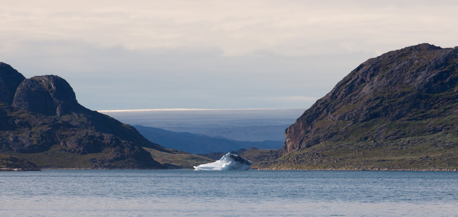
The density of icebergs dramatically increased once we turned into Narssaq Sund making us suspect that Srephensens Havn (60' 56N 46' 11W), our planned anchorage was already inhabited. With binoculars we could see the main bay was crowded with bergs but we decided to take a closer look just in case our anchorage, which was an offshoot of the bay had remained ice free. It had a small berg but nothing alarming and we anchored upwind of our icy neighbor.

After a peaceful night we went to shore to look at the Eskimo ruins which are reputed to be the largest in Greenland with 24 winter houses dating back to 1350. In Greenland though the people refer to themselves as Inuit, they refer to the older remains as Eskimo. All that remained was the evidence of the circular foundations. We walked up to a varde which had a lovely view of the icecap and numerous bergs floating in the sound. On the way down Krystina realized she had dropped 'animal', her fake fur hat. We retraced our way back to the varde, scanning the ground for the well-camouflaged hat. This time we were lucky and were able to find it.
For more photos please click on Stephensens Havn Album.