
From Battle Harbour we intended to stop
at Red Bay on Labrador’s south coast, a newly recognized World Heritage site for
its Basque fishing and whaling history. But when we entered the Strait of Belle Isle, and found the usually windy strait completely calm, we decided to continue
on to Newfoundland turning our planned day sail into an overnight passage. Finally
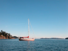
at midnight, after spending the day motoring, the wind filled in from the NE
and we comfortably sailed at 6 knots with a beautiful full moon lighting the
way. The fast downwind sailing continued until we reached Boone Bay a couple
hours after sunset the following day. After looking over the anchorage options
in Boone Bay we settled on Needy Bay, as it seemed well charted and straightforward
enough to enter in the dark.
In the morning after catching up on
our sleep, we pulled anchor and headed for the town of Woody Point just across
the bay. On the way out of Needy Harbour we realized that there are uncharted
rocks that come across a good portion of the entrance on the north side. Luckily
Krystina had favored the south side as we came into the bay and didn’t get near
the partially submerged rocks.


The cruising guide mentioned limited
dock space at Woody Point but said nothing about anchoring. From the chart we
figured there should be reasonable depth on the south side of the town and
ended up anchoring just off the general store with a spectacular view of golden mountains. While wandering around town we came across a tour bus group who were
looking for souvenirs, particularly books, and we told them their was a shop a
short walk away that probably had what they were looking for but they didn’t
want to risk the bus leaving without them and didn’t stray more than a block or
two away.


After a quite night at Woody Point, we
moved further into Boone Bay and anchored in Lomond Cove just off of Gros Morne
National Park. The warm, sunny day was perfect for hiking and we walked along
the trail to Stanleyville where there are the remains of a sawmill built in
1899. At the trailhead was a large bin full of gravel with a sign asking hikers
to take a small bucket of gravel with them to place along the trail where
needed. Frances grabbed a bucket and filled it two-thirds of the way thinking
she wouldn’t have to carry it very far before finding an area that was in need
of new gravel. The trail was well clearly well maintained and we walked for
over a mile before Frances found a minor discrepancy in the surface, or at
least an excuse to get rid of the gravel and hung the empty bucket on a tree
branch encroaching on the trail to remind us to pick it up on the way back.


A third of the way we met a couple
with a dog and young son coming from the other direction. As they passed, they
said we were braver than they were, indicating that they had decided to turn
around, and blessed us. Considering the trail was listed as moderate, we were a
little mystified and were still mystified once we reached the other end as it
was indeed a fairly leisurely trial with a bit of an incline. The site of the
old mill turned out to be a beautiful wooded bay, with only the one old piece
of machinery still visible on the far side of the river.


While we were wandering around trying
to find more evidence of the sawmill we noticed a sign warning that we were in
a hunting area. Gros Morne National Park is protected and we hadn’t realized
that the trail had taken us outside the park boundaries. On our way back we
noticed a large amount of loose fur on the trail and came across a skeleton of
a moose, next to a no hunting sign. The unfortunate moose had only been a few
feet away from safety.


On the dock we met a family who were
camping for the weekend. They mentioned that there was a nice trail around a
lake nearby and warned us that it was supposed to rain the following day. Sure
enough dark cloud rolled in overnight and it was lightly raining by morning. We
decided to chance the weather and went to shore layered in Gore-Tex in search
of the lake trail. We didn’t find the trail but did find a Newfoundland road
map amongst the other information pamphlets in the Park’s cooking hut,
something that had been impossible to find in Woody Point. By this point it was
pouring but that didn’t stop us from admiring some pitcher plants, the official
flower of Newfoundland and picking wild shaggy mane mushrooms for dinner.

Since it was still raining and we were
already soaking wet by the time we returned to Snow Dragon, we pulled anchor
without bothering to change and sailed back to Woody Point in the warm rain.

For more photos please click on Labrador To Newfoundland Album
No comments:
Post a Comment